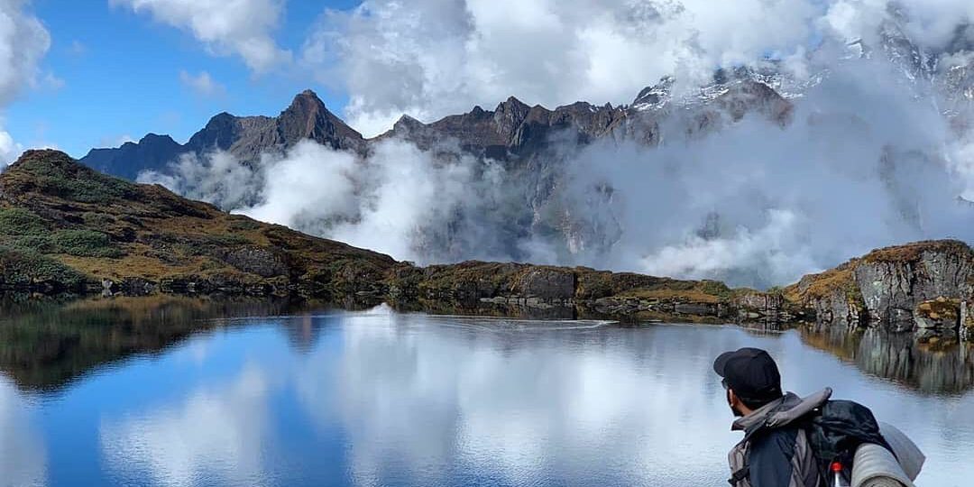
Makalu Barun National Park was established in 1991 AD as the eighth National Park of Nepal with a spread of 1500km2. Similarly, in 1999 AD, an area of 830 km2 surrounding the park was declared as a buffer zone. It covers two districts, namely Shankhuwasabha and Solukhumbu encompassing 4 Rural Municipalities. MBNP extends from an elevation of 435mm with tropical forests along the Arun River to Mt. Makalu (8,463 m), the fifth highest peak in the world and the fourth highest peak in Nepal. Besides Mt. Makalu, there are several other important Himalayan peaks such as Mt. Chamlang (7,319m), Mt. Baruntse (7,129m), and Mera Peak (6,654m), etc. This protected area supports diverse ecosystem types and rich biodiversity therein.
The Makalu Barun National Park area falls in the Eastern Himalayan Climatic region where the monsoon starts early (June) and stays longer than that in west Nepal (till late September). The climate is generally described as monsoon type, where more than 70% of the precipitation occurs between June and September. Pre-monsoon rain is common during the month of April and May. Great variations in temperature and precipitation can be expected due to a wide difference in altitude, slope, and aspect within the area. The park management approach encourages local people to engage actively in managing biodiversity and natural resources and in promoting their own rich cultural heritage.
Traditional resource management systems, such as community-controlled grazing and forest guardianship are being strengthened and low technologies are introduced where appropriate. To ensure active peoples’ participation, 30-50 percent of the park’s revenue is plowed back to the Buffer Zone communities to implement their priority activities.

Table of Contents
Makalu Barun National Park Major Flora and Fauna
Makalu Barun National Park is recognized for its tremendous biodiversity. It harbors 25 species of rhododendron, 47 types of orchids, and 56 rare and endangered plants in 27 types of forests. Snow Leopard (Panthera uncia), Himalayan Black Bear (Ursus thibetanus), Red Panda (Ailurus fulgens), Musk Deer (Moschus chrysogaster), Wild Boar (Sus scrofa), Himalayan Tahr (Hemitragus jemlahicus ) and Common Leopard (Panthera pardus) are major among the 88 recorded mammals. In addition, 433 species of birds have been recorded here.
Fact Sheet of Makalu Barun National Park
| Makalu Barun National Park and Buffer zone | ||
| National Park declared Year | 1991 AD | |
| National Park area | 1500 km2 | |
| Location | North-eastern Nepal (Sankhuwasabha & Solukhumbu district) | |
| Bio-climatic zone | Tropical to Nival | |
| Elevation | 435m (Barun valley) – 8463m (Mt. Makalu) | |
| Major peaks | Mt.Makalu (8463 m), Mera peak (6654m), Mt. Chamlang (7319m) and Mt. Baruntse (7129m) | |
| Major Rivers | Arun, Barun, Saldima, Kasuwa, Isuwa, Apsuwa, Sankhuwa, Hangu, and Inkhu | |
| Main Mammals | Musk deer, Himalayan black beer, Red panda, Snow leopard, Himalayan tahr, Barking deer etc. Main birds Himalayan monal (Danphe), Spiny babbler etc. | |
| Major tree | species Shorea robusta, Pinus spps. Quercus spps., Betula utilis, Rhododendron spps., Acer spps.Taxus walichiams, Juniperus spps.etc. | |
| Buffer zone declared | 1999 AD | |
| Buffer zone area | 830 km2 | |
| Rural Municipalities | 4 (Bhatkhola, Makalu, Silichong and Mahakulung) | |
| Buffer zone user committee | 94 | |
| Population | 38977 | |
| Major ethnic groups | Rai, Sherpa, and Singsawa(Bhote) | |
| Economy | Agriculture, animal husbandry, trade, and labor | |
Entry fee of Makalu Barun National Park
| Makalu-Barun National Park | NRs. 100 per person per entry | NRs. 1,500 per person per entry | NRs. 3,000 per person per entry | Below 10 yrs free |
Major Attractions Makalu Barun National Park
- Makalu (8,463m), Mera peak (6654m)
- World’s deepest Arun valley (435m)
- Snow leopard, Musk deer, Red Panda, and Himalayan Monal
- Moths and Butterflies
- Rhododendron
- Sherpa culture and Monasteries
Accommodation in Makalu Barun National Park
There are several hotels and lodges, local tea shops, and campsites in the park and its buffer zone that offer modern amenities.
How to get into Makalu Barun National Park
There are daily flights to Tumlingtar from Kathmandu. Similarly, there are two flights per week from Biratnagar. Tumlingtar can also be reached by a four-wheeler from Biratnagar and Dharan. It is a 6-7 hour drive from Dharan. You can also reach Inkhu valley of Makalu Barun National Park from Lukla and Phaplu of Solukhumbu district. There are regular flights from Kathmandu to Lukla/Phaplu.
Trekking routes of Makalu Barun National Park
- Tumlingtar–Khandbari–Chichila–Num–Seduwa–Tansigaun–Khongma–Dobatey–Yangle Khark Langmale– Makalu Base Camp.
- Tumlingtar–Khandbari–Bumlingtar–Sisuwatar–Tamku- Naghitar–Deurali–Khyampalung Nurbu Chaur–Nurbu Gaun–Seduwa–Tansigaun–Khongma–Dobatey–Yangle khark–Langmale–Makalu Base Camp.
- Tumlingtar–Chewabesi–Bumlingtar–Budhabare–Chittre–Guranse–Bakang–Kamere–Kenpa–Kaal Pokhari/Gouvitta–Jumley Pokhari–Khultumla–Bagaley Deurali–Mandre/Katrey Odhar–Sikari Odhar–HUnhu Khola- Chir Khola–Gopi Chaur–Urpha Tar–Khongmading–Mera Peak.
- Tumlingtar–Khandbari–Num–Pathibhara–Gola–Tutin-Yanglekhark–Makalu basecamp.
- Taplejung–Thudam–Chepuwa–Hattiya–Gola–Jante Odhar–Yangle khark–Langmale– Makalu Base Camp.
- Lukla–Pangomg–Bhasme–Najing–Cholem–Kolakharka-Kothe–Thangnak–Khare (Mera Peak Base Camp).
Safety Precautions
Most trails are quite sheer rocky and become slippery after rain and snow. Until April or May, winter snows generally stay on the passes and on high-altitude trails. One particular hazardous area is the trail between Mumbuk and Yangle because of unstable and dangerous rockfall. Trekkers in this area should move quickly and watch for falling rocks. Mountain sickness can also be a serious risk if elevation gains are rapid without proper acclimatization.
National Park General Code of Conduct
Follow the minimum impact code while trekking so that you and your host (local nature and people) benefit for indefinite years to come. Because what you benefit from a particular tourism destination at present and future largely depends on how you impact the local environment and culture.
Conserve forests
- The use of firewood is prohibited.
- Don’t light a campfire. Cook with kerosene or gas and take sufficient warm clothing.
- Choose lodges that use alternatives to wood for cooking and heating.
Stop Pollution
- Carry out what you carry in.
- Buy only what won’t pollute, or carry it out.
- Use safe drinking water or purify water yourself.
- Do not use polythene/plastic materials.
- Take only photographs, leave only footprints.